Most riders who attempt the Ha Giang Loop without a proper map miss the best of it. Not because the road is hard to follow — but because the Loop is not one road. It is a 350-kilometer closed circuit of interconnected highland highways, branching passes, and unmarked detours through Vietnam’s wildest northern province, where Google Maps runs out of useful information long before the mountains run out of scenery.
For first-time riders especially, knowing how many days to allocate, which direction to ride, and which transport option suits their style transforms the Loop from a logistical challenge into a coherent journey. After the full route breakdown and key stops, this guide also covers the practical intelligence most maps leave out — offline navigation tools, fuel gaps in remote segments, and how the Loop map changes between dry and wet seasons. Together, this is the complete Ha Giang Loop map guide you need before the first kilometer begins.
What is Ha Giang Loop Map?
The Ha Giang Loop is a circular motorbike route that starts and ends in Ha Giang City, covering roughly 350 kilometers through the Dong Van Karst Plateau Geopark — a UNESCO-recognized geological reserve in Vietnam’s far north, approximately 320 kilometers from Hanoi.
To understand the Loop map properly, picture it not as a single highway but as a closed circuit with four distinct arcs, each offering completely different terrain, elevation, and cultural character. The route passes through Ha Giang Province — bordered by China to the north — and crosses the traditional territories of the H’Mong, Tay, Lo Lo, Pu Peo, and other highland peoples whose villages, markets, and centuries-old architecture appear directly alongside the road. This combination of extreme topography and living cultural density is what makes the Ha Giang Loop unlike any other motorbike route in Vietnam or Southeast Asia.
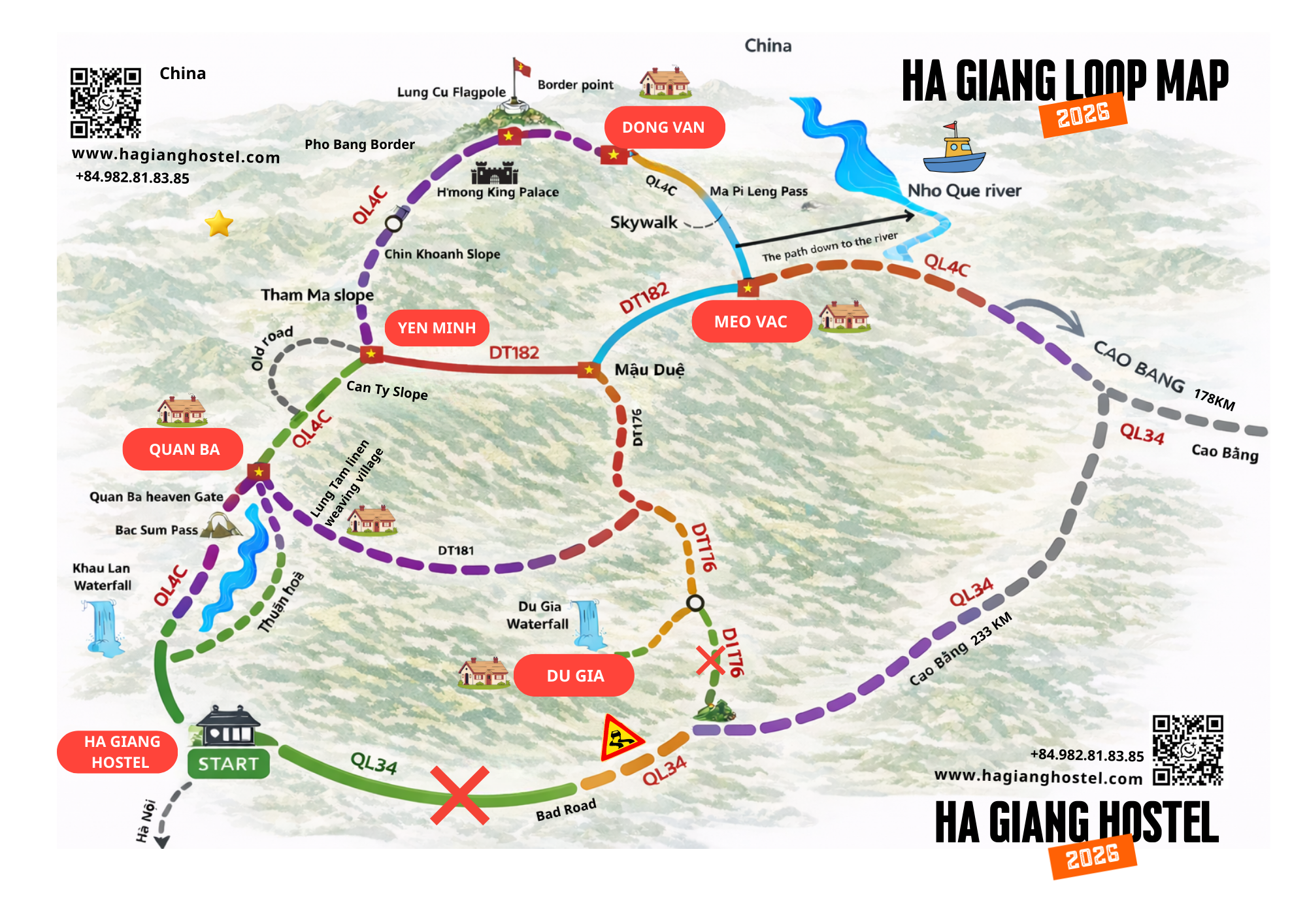 Specifically, the Loop traces a path through four mountain districts of the Dong Van Karst Plateau: Quan Ba, Yen Minh, Dong Van, and Meo Vac. Elevations shift dramatically along the way — from Ha Giang City sitting near 100 meters above sea level to mountain passes breaching 1,500 meters. Road surfaces range from well-paved national highway (QL4C) to narrow gravel-strewn district roads where average riding speed drops to 20 km/h or less. That variation is precisely why a dedicated Loop map — not just a phone GPS — is essential equipment for this journey.
A proper Ha Giang Loop map differs from Google Maps in several critical ways. Standard navigation apps frequently route riders onto unmarked mountain trails, omit fuel station locations, and provide no information about road surface conditions, active landslide closures, or safe viewpoint pull-offs. The Loop map used by experienced riders layers in waypoints for fuel stops, homestay clusters, pass summits, ethnic village markets, and mobile signal dead zones — all information that becomes genuinely critical once you leave the main highway behind Yen Minh.
Which Road Segments Make Up the Ha Giang Loop Map?
The Ha Giang Loop map consists of four primary road segments, each with its own distance, riding character, and level of challenge. The table below summarizes each segment’s key attributes — distance, difficulty, and signature feature — to help riders allocate time and physical energy across the full circuit:
| Segment | Route | Distance | Difficulty | Key Feature |
|---|---|---|---|---|
| 1 | Ha Giang City → Quan Ba | ~46 km | Moderate | Bac Sum Pass, Heaven’s Gate, Twin Mountains |
| 2 | Quan Ba → Yen Minh → Dong Van | ~80 km | Moderate–Hard | Tham Ma slope, Pine Forest, M-shaped curve |
| 3 | Dong Van → Meo Vac | ~24 km | Hard | Ma Pi Leng Pass, Nho Que River gorge |
| 4 | Meo Vac → Du Gia → Ha Giang City | ~130 km | Moderate | Du Gia village, Tham Luong waterfall, return descent |
- Segment 1 (Ha Giang City → Quan Ba, ~46 km) is the opening act and serves as a physical introduction to what the Loop demands from a rider. The Bac Sum Pass — the first serious ascent of the trip — climbs via a series of steep switchbacks on fully paved road. At the top, Quan Ba Heaven’s Gate opens at approximately 1,200 meters elevation, delivering the first panoramic view of the limestone valley below. Just beyond lies the Quan Ba Twin Mountains, also called the Fairy Bosom Hills, one of the most photographed natural formations in northern Vietnam and a reliable signal that the plateau proper has begun.
- Segment 2 (Quan Ba → Yen Minh → Dong Van, ~80 km) is the longest arc on the Loop map and the most varied in character. The road passes through the Yen Minh Pine Forest — a dense, fog-wrapped highland stretch that riders often compare to the pine zones of Da Lat — before encountering the famous Tham Ma slope, a legendary S-curve that has become one of the Loop’s signature photographic stops. The final approach into Dong Van crosses the celebrated M-shaped road (also called the Z-road or Chu M curve), a series of hairpin bends that appear from altitude as a perfect geometric shape against the green hillside and are beloved by drone photographers.
- Segment 3 (Dong Van → Meo Vac, ~24 km) is the shortest segment by distance and unquestionably the most intense by experience. This is the crossing of Ma Pi Leng Pass — carved directly into vertical cliff faces above the Tu San Canyon and the Nho Que River far below. Despite its brevity in kilometers, the emotional and visual weight of this segment makes it the defining passage of the entire Loop. Riders should plan at least 1–2 hours for stops along this stretch — not just for safety, but because the scenery demands unhurried attention.
- Segment 4 (Meo Vac → Du Gia → Ha Giang City, ~130 km) is the return leg and the one most consistently underestimated by first-time planners. The road south from Meo Vac through Mau Due and into Du Gia offers some of the Loop’s most serene valley scenery — layered rice terraces, floating cloud lines at dawn, and far fewer tourists than the northern segments. Du Gia village is a natural final overnight stop before returning to Ha Giang City, and the Tham Luong Waterfall 3 km outside the village rewards early risers with a refreshing swim in clear mountain water before the long road home.
Clockwise or Counter-Clockwise: Which Direction Works Best on the Ha Giang Loop Map?
Riding clockwise — Ha Giang City north to Quan Ba, east to Dong Van, south to Meo Vac — is the better direction for first-time riders, offering a more gradual elevation build-up and positioning Ma Pi Leng Pass for its most dramatic approach: arriving from Dong Van heading southwest, with the full gorge view opening ahead as the road begins its descent toward Meo Vac.
Riding counter-clockwise — Ha Giang City directly south to Du Gia, then north to Meo Vac — is preferred by some experienced riders who want to avoid the majority of tourist traffic concentrated on the clockwise direction. Counter-clockwise also means riding Ma Pi Leng from Meo Vac toward Dong Van, which delivers a slightly different visual experience at the pass summit and the advantage of a quieter Dong Van arrival. For the vast majority of visitors, however, clockwise remains the recommended choice. It front-loads the most accessible segments, builds riding confidence before the technical demands of Ma Pi Leng, and creates the natural narrative arc — from opening beauty through maximum intensity to quiet return — that the Loop’s geography was made for.
The Mountain Passes of the Ha Giang Loop
The Ha Giang Loop contains four major mountain passes — Ma Pi Leng, Tham Ma, Chin Khoanh, and Quan Ba — each positioned at a specific location on the Loop map with distinct elevation profiles, road widths, and scenic character.
Understanding where each pass sits before you ride is not merely useful for planning — it is essential for safety. These passes involve steep gradients, tight hairpin bends, exposed cliff edges, and road surfaces that change dramatically in wet weather. The table below maps each pass against the factors that matter most to riders preparing the route:
| Pass | Location on Map | Elevation | Width | Difficulty | Defining Feature |
|---|---|---|---|---|---|
| Ma Pi Leng | Dong Van → Meo Vac | 1,200–1,500 m | Narrow, paved | ★★★★★ | Tu San Canyon, Nho Que River gorge |
| Tham Ma (Dốc Thẩm Mã) | Quan Ba → Yen Minh | ~1,000 m | Paved, S-curve | ★★★☆☆ | Legendary S-bend, buckwheat flower fields |
| Chin Khoanh | Yen Minh → Dong Van | ~1,100 m | Paved, switchbacks | ★★★★☆ | Panoramic plateau views, Lung Cu fork |
| Quan Ba / Bac Sum | Ha Giang City → Quan Ba | ~1,200 m | Paved, steep | ★★★☆☆ | Heaven’s Gate, Twin Mountains below |
![Ma Pi Leng Pass cliff road above Nho Que River gorge Ha Giang Vietnam]
Ma Pi Leng on the Loop Map
Ma Pi Leng Pass sits between Dong Van and Meo Vac on the Loop’s third segment, at approximately 23.17°N, 105.38°E, and is regarded by most riders and travel authorities as the most spectacular mountain road in Vietnam — and among the finest in all of Southeast Asia.
The pass stretches roughly 20 kilometers and climbs between 1,200 and 1,500 meters above sea level. What sets Ma Pi Leng apart from every other pass on the Loop — and from most mountain roads in the region — is the nature of its terrain. The road is not cut across a ridgeline or switchbacked up a gradual slope. It is blasted directly into vertical limestone cliff faces, with the Tu San Canyon dropping nearly 800 meters straight down to the right and the Nho Que River visible far below as a ribbon of improbable green. There is no gentle gradient here — only sheer rock wall on one side and open sky above a dizzying void on the other.
At the Ma Pi Leng viewpoint — positioned roughly at the emotional midpoint of the pass — riders stop to take in the canyon below. This is among the most visited single viewpoints in northern Vietnam. Morning light between 8am and 10am is the optimal window: low sun angles illuminate the river’s mineral-green water before the canyon floor drops into shadow for the rest of the day. Riders arriving after 2pm frequently find the gorge in near-complete shade, and the visual impact is significantly diminished.
Dốc Thẩm Mã (Tham Ma Slope)
Dốc Thẩm Mã (Tham Ma Slope) sits between Quan Ba and Yen Minh and is best known for its S-shaped double switchback, which appears from a hilltop vantage just above the upper curve as a perfect geometric shape against a steep green hillside. This is among the most photographed road features in Vietnam, and the pull-off viewpoint is consistently busy throughout the riding season. The slope itself is fully paved and manageable for intermediate riders, but the narrow lane and the frequency of tourists stopping for photographs require patience. In October and November, the surrounding hillside fields bloom with buckwheat flowers (hoa tam giác mạch) — a deep purple-pink that makes the visual impact of the Tham Ma viewpoint uniquely seasonal and exceptionally photogenic during that window.
Đèo Chin Khoanh
Đèo Chin Khoanh sits between Yen Minh and Dong Van and is arguably the most underrated pass on the entire Loop. Less frequently highlighted in travel content than Tham Ma or Ma Pi Leng, Chin Khoanh offers a long series of climbing switchbacks through pine-edged terrain before opening onto expansive plateau views on the northern face. Near the summit, the QL4C highway passes a critical fork: continuing south leads to Dong Van, while the northern branch on the DT182B road leads toward Lung Cu Flag Tower at Vietnam’s northernmost point. This junction is one of the most important decision points on the entire Loop map, and riders who miss or ignore it lose access to the Lung Cu detour entirely.
Đèo Quản Bạ (Bac Sum / Heaven’s Gate)
Đèo Quản Bạ (Bac Sum / Heaven’s Gate) is the Loop’s opening pass and its most accessible. Climbing from Ha Giang City on the QL4C, riders ascend to approximately 1,200 meters where Cổng Trời (Heaven’s Gate) marks the threshold between the lowland valley and the plateau above. The viewpoint looks directly down at Tam Son Town nestled in the valley and the iconic Quan Ba Twin Mountains — two symmetrical dome-shaped limestone hills rising from flat paddy fields, which local legend describes as the breasts of a fairy who fell in love with a mortal man. For riders encountering the Ha Giang landscape for the first time, Heaven’s Gate is the moment the journey becomes real.
The Ha Giang Loop Stops Map Must-Visit Points by Segment
The Ha Giang Loop stop map contains three categories of essential points: natural viewpoints, cultural and historical landmarks, and community rest stops — distributed across all four route segments, with the highest concentration of significance between Dong Van and Meo Vac.
Planning which stops to prioritize matters because the Loop contains more points of genuine interest than any 3–4 day ride can comfortably absorb. Grouping stops by segment and matching them to light conditions, market days, and daily energy levels is the most effective approach to getting the most out of the map.
Must-Stop Points from Ha Giang City to Dong Van
The first two segments of the Loop map — from Ha Giang City through Quan Ba and onward to Dong Van — contain six essential stops, each serving a different function in the journey’s overall narrative.
Km0 Milestone, Ha Giang City
Every Loop ride begins at the Km0 stone marker in Ha Giang City: a symbolic starting line before the mountains take over. Most riders photograph it as a record of departure. It also functions as the orientation point from which all distances on the map are measured.
Quan Ba Twin Mountains (Núi Đôi)
Visible from Heaven’s Gate above and framed by the valley road below, the Twin Mountains are among northern Vietnam’s most recognizable natural formations. The surrounding Tam Son valley offers the clearest ground-level perspective, especially in morning mist — common between October and March — when low cloud partially obscures the peaks and creates a landscape that seems to exist somewhere between geography and legend.
Yen Minh Pine Forest (Rừng Thông Yên Minh)
Positioned between Quan Ba and Yen Minh town, this pine-covered highland stretch is unlike anything else on the Loop. The dense canopy creates filtered light, a noticeably cooler temperature, and an atmosphere of unusual quiet. Riders frequently describe it as the most peaceful section of the entire circuit and compare it to the highland pine zones of Da Lat. It is most beautiful in early morning, when ground mist threads through the lower trunks and the light comes in low and golden through the trees.
Dốc Thẩm Mã Viewpoint
As detailed in the passes section, the S-curve viewpoint above Tham Ma is one of the Loop’s signature photographic stops. In October and November, the surrounding hillsides bloom with buckwheat flowers — Ha Giang’s most celebrated seasonal event — transforming the entire landscape into shades of deep purple and soft pink that no other time of year replicates.
Phố Cáo Village
Between Yen Minh and Dong Van, Phố Cáo is a small H’Mong settlement built entirely of traditional earthen-wall construction (nhà trình tường) — thick rammed-earth walls that insulate against the highland cold and give the village an architectural coherence that feels genuinely ancient. The buckwheat flower fields surrounding Phố Cáo are among the most concentrated on the Loop in season. Outside flower season, the village remains worth the stop for its architectural character and the unhurried pace of daily life visible from the roadside.
M-Shaped Road (Cua Chữ M / Z-Road)
On the final approach to Dong Van via QL4C, this sequence of dramatic switchbacks is best appreciated from a hilltop vantage point north of the road. From the right elevation, the road traces a shape that is impossible to fully register from the saddle — making the short detour to the hillside viewpoint worthwhile for anyone carrying a drone or a telephoto lens.
Must-Stop Points from Dong Van to Meo Vac and the Return Leg
The final two segments contain the Loop’s most historically significant and geographically dramatic stops — concentrated in a 50-kilometer corridor between Dong Van and Meo Vac that most riders describe as the emotional heart of the journey.
Lung Cu Flag Tower (Cột Cờ Lũng Cú)
A 24-kilometer detour north from the QL4C junction near Dong Van, Lung Cu marks the geographic northernmost point of Vietnam. The 33-meter tower flies a 54-square-meter national flag representing Vietnam’s 54 ethnic groups. Reaching the summit requires climbing more than 800 stone steps — or riding partway by motorbike to reduce the climb to roughly 283 steps. On clear days, the Chinese border is visible from the top. The combination of physical effort, national symbolism, and geographic extremity makes this one of the most emotionally resonant stops on the entire Loop.
Nhà Vương (H’Mong King’s Palace / Dinh Vua Mèo)
Located near Sa Phin village between Dong Van and the Lung Cu junction, this historic compound was built between 1919 and 1928 by Vuong Chi Sinh — the most powerful H’Mong chieftain of the colonial era. The architecture blends traditional H’Mong construction with Chinese and French colonial influences: a physical record of the complex political negotiations of a particularly volatile period in northern Vietnam’s history. Entry costs 30,000 VND. The surrounding valley context and the building’s layered architectural story make it one of the Loop’s most historically textured stops.
Dong Van Old Quarter (Phố Cổ Đồng Văn)
The old quarter is a cluster of stone-built trading houses constructed primarily in the late 19th and early 20th centuries, many using walls of locally quarried Dong Van limestone. The periodic market (chợ phiên), held every Sunday, brings together traders and minority community members from across the plateau in an atmosphere that remains genuinely functional rather than staged for tourist consumption. Staying overnight in Dong Van — preferably at a homestay within the old quarter — allows riders to experience the town at dawn and dusk, when the limestone facades catch the low light and the streets are quiet enough to actually listen.
![Dong Van Old Quarter stone buildings limestone Ha Giang ethnic market Vietnam]
Ma Pi Leng Pass and Nho Que River Boat Trip
As covered in the passes section, this is the Loop’s defining natural experience. The boat trip on the Nho Que River, departing from Meo Vac, adds approximately 2 hours to the Ma Pi Leng segment and is strongly recommended for any rider whose schedule can accommodate it. The river’s color — an almost artificial shade of emerald green caused by mineral content and light refraction deep in the canyon — is unlike any water seen elsewhere in Vietnam and is best experienced between 9am and noon when sunlight reaches the canyon floor.
Du Gia Village and Tham Luong Waterfall
The final significant stop before the return to Ha Giang City, Du Gia sits in a broad valley of unusual tranquility. The village is home to Tay minority families and offers several good homestay options. The Tham Luong Waterfall, 3 kilometers from the village center, cascades into a natural swimming pool that serves as the Loop’s most refreshing natural stop — a logical place to mark the end of the main circuit before the final highway drive back to the city.
Ha Giang Loop Itinerary by Days — Should You Ride 3, 4, or 5 Days?
A 4-day itinerary is the best balance for the majority of riders: long enough to absorb the Loop’s essential highlights without rushing any of them, short enough to avoid the cumulative fatigue that builds by day 5 on mountain roads. Three days compresses too much into each riding session; five days offers genuine depth but requires specific off-loop extensions to fill the schedule meaningfully.
The 3-day itinerary
The 3-day itinerary is the minimum viable Loop and works only for riders who have ridden the circuit before, are physically confident on mountain terrain, and accept that secondary stops will be skipped entirely. Day 1 covers Ha Giang City to Dong Van — approximately 120 km including all the Quan Ba and Yen Minh segments. Day 2 handles the Dong Van to Meo Vac segment with the Lung Cu detour — short in kilometers but extremely time-intensive given the climbing and stop density. Day 3 returns through Du Gia to Ha Giang City — roughly 130 km with minimal rest. This schedule leaves no margin for poor weather, mechanical issues, or the spontaneous stops that are often the most memorable moments on the Loop.
The 4-day itinerary
The 4-day itinerary is the recommended standard for first-time riders. The circuit divides into four manageable daily stages that match the natural geography of the route:
- Day 1: Ha Giang City → Quan Ba → Yen Minh (~80 km). Morning at Km0 and Bac Sum Pass, midday at Heaven’s Gate and Twin Mountains, afternoon at Tham Ma slope and Yen Minh Pine Forest. Overnight in Yen Minh.
- Day 2: Yen Minh → Dong Van (~50 km). Morning through Phố Cáo village, the M-shaped road approach, afternoon at Nhà Vương and Dong Van Old Quarter. Overnight in Dong Van.
- Day 3: Dong Van north to Lung Cu detour → Ma Pi Leng Pass → Meo Vac (~70 km total). Full day with two major highlights requiring concentrated time. Overnight in Meo Vac.
- Day 4: Meo Vac → Du Gia → Ha Giang City (~130 km). Morning swim at Tham Luong, quiet valley riding through Mau Due, return to Ha Giang City by late afternoon.
The 5-day itinerary
The 5-day itinerary suits riders who want to extend into the supplementary routes — particularly the Du Gia trekking circuit, the full Nho Que River boat experience, or a connection ride toward Bao Lac and eventually Ban Gioc Waterfall in Cao Bang Province. Day 5 also functions as a natural weather buffer: one of the most common sources of Loop disruption is a rain delay that adds unexpected hours to a single segment. For Easy Rider arrangements, guides naturally pace the journey more slowly and include culturally specific stops that self-riders typically miss, making 5 days the more appropriate baseline.
The Ha Giang Loop map is ultimately a document of choices — which passes to linger on, which villages to sleep in, which fork in the road to take when the main route branches into two entirely different landscapes. The riders who get the most from it are the ones who treat it not as a fixed itinerary but as a living framework, adjusted in real time to weather, energy, and the pull of whatever appears around the next corner.
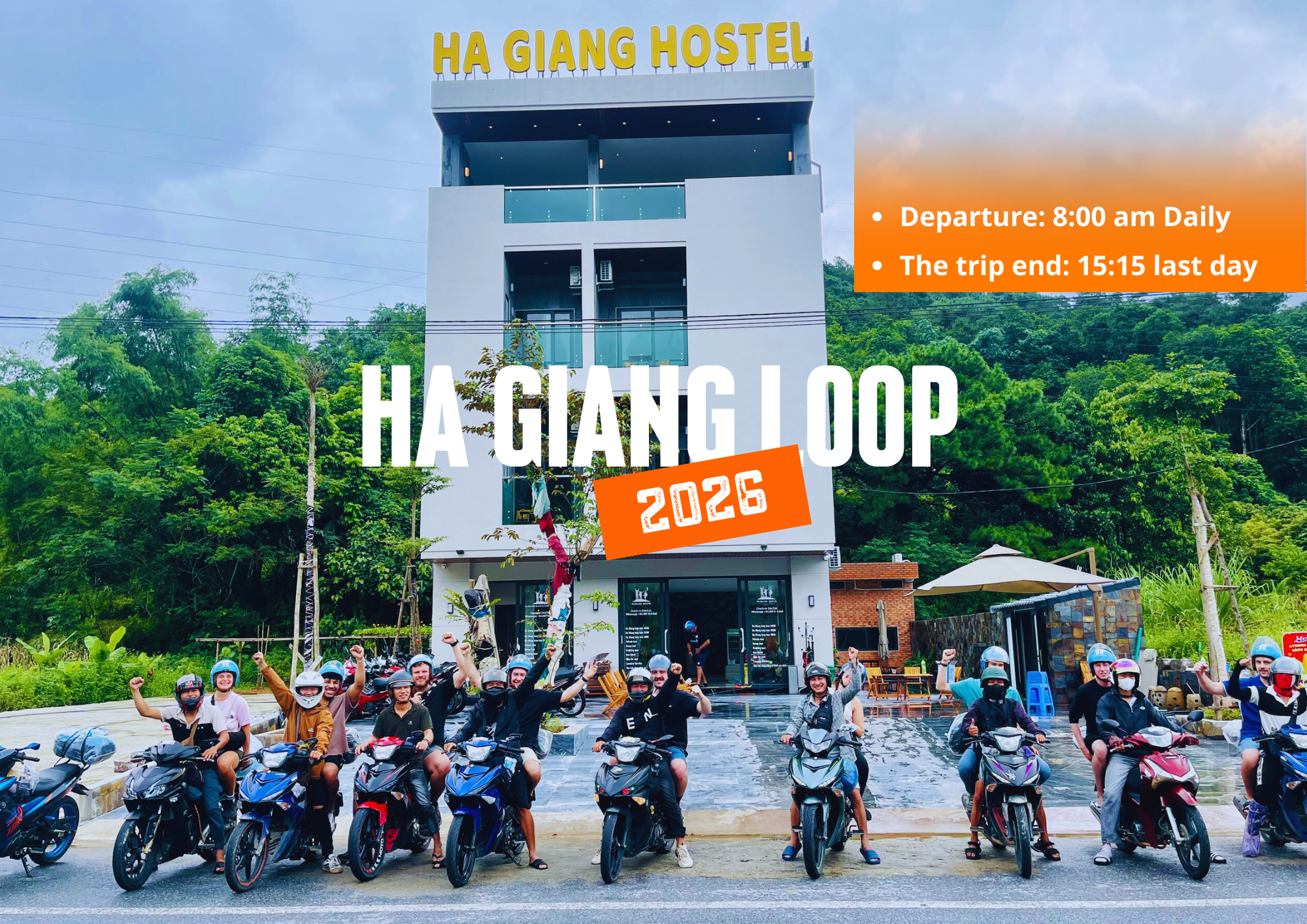
If you’re looking to book a Ha Giang Loop tour, feel free to contact Ha Giang Hostel for expert advice and personalized recommendations.